Hockett Trail: Cottonwood Creek Revisited

Old trail accounts from the Sierra Club Bulletin appear to indicate that the old Hockett Trail may have followed Little Cottonwood Creek.

Back in January 2009, I posted a brief discussion on a letter or note in Volume III of the Sierra Club Bulletin, dated 1899–1900. I think a passage from that letter calls for some reconsideration:

From Round Valley down to where it leaves the Little Cottonwood the old Hockett Trail is almost untraveled. The shorter route now in use leaves the valley at the lower end, drops over the Big Cottonwood, descends this past an old sawmill, and crosses to the Little Cottonwood, which it reaches about fifty yards below where it rejoins the old trail, at the foot of the Devil’s Ladder.

E. B. C., Sierra Club Bulletin, Vol. III., No. 2, May 1900

This apparent “letter to the editor” describes a new trail, more commonly traveled than the “old Hockett Trail.” The letter implies that the old trail went from Round Valley (below Trail Pass) to Little Cottonwood Creek, followed and then left the Little Cottonwood, perhaps, not far from where Horseshoe Meadows Road crosses the Little Cottonwood today.

Continue reading

The Cut-Off

There were no trails across the Great Western Divide until the early Twentieth Century. Though some travelers crossed the Divide, most took the Hockett Trail around it. Parties would often take this circuitous route to reach destinations that are now accessed in a fraction of the distance, thanks to the high-tech expressways—er, trails—of the Twentieth Century.

Progress!

The Hockett Trail was completed by Union troops during the Civil War as a light pack trail, with the intention of replacing the trail with a wagon road. There was no dynamite and no steel involved. The stream crossings and slopes were moderate. It was a route that a pack train could follow without any engineering at all.

In 1879, a mining road was completed to the valley of Mineral King, in anticipation of riches that never quite materialized. With this road, the western segment of the Hockett Trail would be bypassed by parties heading around the Divide. The new road was cut through treacherous terrain—not a natural route, but a direct cut through a canyon. From then on, getting around the Divide generally meant crossing Farewell Gap from Mineral King and meeting the Hockett Trail in Little Kern country.

The trail from Mineral King met the Hockett Trail where the latter crossed the Little Kern River, just east and downstream of Wet Meadows.

The trail drops rapidly from the summit of the ridge to the Little Kern, where it is joined by the trail from Mineral King.

Mount Whitney Club Journal, May 1903

The Hockett Trail west of the Little Kern developed a reputation as a rough trail, but this was probably because it was nearly abandoned after Mineral King Road was completed. That decline ended soon after the creation of Seqouia National Park in 1890. As before, the Hockett Trail was the labor of soldiers.

I have stated that the Hockett trail is the worst in the mountains. It has been greatly improved within the last year or two by the soldiers stationed in the Sequoia National Park.

Mount Whitney Club Journal, May 1903

The first trail blazed over the Great Western Divide appears to have been more circuitous than the current Coyote Pass route that replaced it.

During the summer of 1900 Forest Ranger, Ernest Britten marked out a trail from the vicinity of Bullion Flat (southeast of Mineral King and Farewell Gap) to the lakes on Kern River.

Mount Whitney Club Journal, May 1903 — Important Trail Work, pg. 83

The cut-off was soon re-routed and improved, and by Summer 1902 much of the old circuit around the Divide was largely abandoned. Soon after that, a bridge was built across the Kern River, and the old ford was abandoned as well. This, in turn, meant the old trail up the north side of Volcano Creek was also abandoned.

Early in the year 1901 the Visalia Board of Trade expended more than one hundred dollars on the “cut-off” from the vicinity of Bullion Flat to Kern River, improving the grade, and shortening the distance of actual travel to less than one half of that of the old Trout Meadow route. This is now the only trail regularly traveled between these points. Money has been appropriated by the bodies previously named herein to further improve this trail and to build a bridge across Kern River. The work will be done with the assistance of the forest rangers and the Mt. Whitney Club as early this season (1903) as the melting snow will permit.

Mount Whitney Club Journal, May 1903 — Important Trail Work, pg. 84–85

Though the original Hockett Trail fell into disuse within about 16 years of its completion, much of it is still maintained, and much of the rest can still be followed without too much difficulty. The old ford is still there, of course, and the route is relatively free of cliffs and dangerous stream crossings. The Hockett route, in fact, is much as it was when the trail was first blazed in 1863.

Hockett Trail Notes: Devils Ladder and Coyote Pass

Taking a moment to process some minutia of Hockett Trail history …

This early account of the rerouting of a short segment of the Hockett Trail appears to corroborate my understanding that the Hockett Trail followed the same route that Horseshoe Meadows Road follows today, only with shorter switchbacks:

From Round Valley down to where it leaves the Little Cottonwood the old Hockett Trail is almost untraveled. The shorter route now in use leaves the valley at the lower end, drops over the Big Cottonwood, descends this past an old sawmill, and crosses to the Little Cottonwood, which it reaches about fifty yards below where it rejoins the old trail, at the foot of the Devil’s Ladder.

E. B. C., Sierra Club Bulletin, Vol. III., No. 2, May 1900

For anyone who’s driven Horseshoe Meadows Road, names like “Devil’s Ladder” should come as no surprise. I’m guessing that this Devil’s Ladder is the name that was given to the eastbound ascent out of the Cottonwood Creek watershed to what is now called “Walt’s Point”, atop the grand descent down “Hockett Hill.”

The following demonstrates that, contrary to what appears to be a common understanding, the Hockett Trail did not cross the Great Western Divide at Coyote Pass:

Another trail in recent use is between Mineral King and the Big Kern, via Coyote (or Quinn’s ) Pass. I think they are the same. From the east it starts at the soda spring and keeps north of Coyote Creek up to the meadows. From the west it leaves the Hockett Trail, perhaps two miles south of Farewell Gap, and is indicated by a signboard—”Poison Meadow Trail.” According to the signs, the “Hockett Trail” leads to Mineral King, and the trail to Hockett Meadows is the “Hockett Meadow Trail.”

E. B. C., Sierra Club Bulletin, Vol. III., No. 2, May 1900

Kern Canyon 2008: Sunday

I returned to Lewis Camp Trailhead by way of Trout Meadows—about 16 miles with 3800 feet of gross elevation gain. Clouds had gathered overnight, so the weather was mild, with only occasional direct sunlight. I would not have minded being rained upon, as it was still possible to overheat. It’s not a bad idea to keep one’s hat wet.

A livestock gate on the Hockett Trail.
There are plenty of livestock gates along the way.

As I ascended out of Kern Canyon, I spotted my second pack train of the trip in the distance. I was taking the steep, rocky shortcut out of the canyon, and I could see the packer leading his animals down the longer, earthy and less strenuous branch. There was something mystical in the silence of that Mexican horseman lazily leading his train down into the canyon.

That train was the beginning of a number of encounters with equestrians—perhaps a half dozen, during which I spooked a dog and a horse, and caused several horses to freeze up with my mere presence. In all my backpacking days, I cannot recall ever having been such a haunting presence on the trail. It’s not that I don’t have the sense to get out of the way. Some animals seem to trust me less for every step I take away from the trail. Perhaps it’s the big heavy ceanothus walking stick that’s spooking them, if not my size 7-3/4 head and size 13 boots.

When I finally got to the trailhead, the SAR base camp was still there. Orders had just gone out to some of the workers to go get some dinner. Two days after I returned home, the Visalia Times-Delta reported details on the missing man.

This trip, I entered and exited the Sierra by way of Frazier Valley—a personal first. When I drive to or from the southern Sierra, I love to see the sinking Sierra foothills jut out of the Valley like surfacing whales. Someday I would like to try doing a photo essay on this beautiful local phenomenon. Somebody ought to!

Kern Canyon 2008: Saturday

Just after six in the morning, just as the moon set over the Western Divide, I left the Jordan Trail, taking the Cutoff Trail that heads over the tail of the Great Western Divide toward Willow Meadows and the Hockett Trail. I followed the trail and a single set of fresh boot tracks, wondering if they might lead me to a stranded hiker. I stumbled across a dozing rattlesnake, camouflaged in the sand of the trail, who barely moved in the cool dawn air.

As I descended over the hump, a helicopter began passing up and down the Trout Meadows kerncol (a kerncol is a type of saddle unique to the Kern Canyon), presumably looking for the missing man.

The luxury campsite at Willow Meadows Junction
The luxury campsite at Willow Meadows Junction.

The mosquitoes also appeared in force as I neared Kern Canyon. I first noticed them at the Trout Meadows spring, a couple of meadows above Willow Meadows Camp. There were several guys preparing to break camp and continue into the canyon as I was, but I didn’t see any sign of them afterward. I’m guessing they turned back when they got to the bottom of the canyon.

I might have turned back at canyon bottom if I hadn’t been familiar with the route, as the trail had been washed out for about a mile along the canyon bottom, from Leggett Creek all the way to the foot of the ascent to the next kerncol. There were no tracks whatsoever, there was saturated mud everywhere, and the flooding—though subsiding—was not completely over. It wasn’t hard hiking if you had some idea about the general route, that is, if you knew the trail generally keeps away from the river, and had faith that it would eventually reappear.

There’s a good campsite just downstream of Legget Creek that looks like it’s about to be washed into the river, and then there’s the site in the heart of Grasshopper Flat, where Juan and I camped five years ago. I like to refer to that camp as “Scorpion Camp”, in honor of a little critter I uncovered while starting a fire back in 2003.

I veered off the main trail at Little Kern Lake to follow a camp trail that wraps around the lake’s north shore, visiting some nice beaches, and a great campsite at the northwest corner of the lake.

A lovely campsite on the northwest shore of Little Kern Lake
A lovely campsite on the northwest shore of Little Kern Lake.

After Little Kern Lake, I beat feet up to the point where the old trail once followed a kerncol that delivers the traveler directly down to Coyote Creek and the Kern Canyon Ranger Station. It may have been a theoretical shortcut, but there was no trail to follow, so I had to apply a couple corrections to my route finding. Though these kerncols can keep the trail safe from the ravages of rock falls and snowmelt, it seems to me that the old route over this particular kerncol was abandoned for good reason. What a workout! The current trail takes advantage of a lower, less strenuous kerncol which I have sworn fealty to in the future.

Having backpacked fourteen miles since dawn, I was trail weary when I arrived at Coyote Creek. I proceeded across the creek, by way of the huge crossing trunk, and headed down to the river, where I expected to find some backcountry campsites. When I got to the river, I threw off my pack, crossed the bridge into Inyo National Forest, and followed the meandering trail through the manzanita flat above the river. I hadn’t secured my pack against critter depredations, so I soon grew worried and doubled back. I then lugged my pack back to Soda Spring, where I had recalled hearing there was a campground. Soda Spring looked rather murky, and there wasn’t a fire ring in sight, so I decided to return to Coyote Creek. I crossed the creek and unrolled my sleeping bag at the foot of the kerncol that I’d taken in. It would work as a campsite, but I felt a little nervous being so close to the ranger station (no permits).

I had walked around with a bag of M&M trail mix in my hand too long. Many of the M&Ms had melted, leaving the mix resembling a loose, nutty stool.

As I collected my things to filter some water and head down canyon to camp, I was hailed by a young biologist, who directed me to the spot I had just forsaken as a good place to camp. She said she was part of a team that is tasked with removing “invasives”. Feeling a bit like an invasive exotic myself in this restored territory behind enemy lines, I told her “I just want to hug my kids.” She offered me an OREO for comfort, but I told her honestly that I was already full of M&Ms. I was dizzy from fatigue, which is the condition that generally leads me to hiking even more. She headed down trail with her fishing pole. I finished the M&M trail mix and headed down the canyon as soon as the coast was clear.

I camped that night at a nice campsite two miles down canyon, just north of the creek that feeds into Big Kern Lake, which is a humorous euphemism for a huge mud hole and would-be malarial swamp. I prepared to keep a companion fire going, and hoped it would repel the West Nile hummingbirds, as I had no tent to hide in. I saw one playing in the smoke and wondered whether smoke repels them or merely distracts them. No dead crows in sight, though I had seen a silly crow on my way down canyon.

I don’t know what the stars were like that night. I let the little fire smolder, read a bit from the Zoroastrian Journal, took two aspirin for my knee, and fell asleep quite effortlessly.

I did have to stir enough to pump the heat out of my wife’s fancy North Face sleeping bag. I might have done better with a bed roll.

Continue to Sunday

Kern Canyon 2008: Friday

This last full moon, I backpacked up to the Kern Canyon stock bridge in Sequoia National Park. I started at Lewis Camp Trailhead, in Sequoia National Monument, just outside the southern boundary of the Golden Trout Wilderness. This trailhead sits near the top of the Western Divide, on the historic Jordan Trail. For many trips that begin there, the trailhead is the highest point of the trip (7600 feet).

Tulare County SAR Jeep

Tulare County Sheriff SAR Jeep

I pulled into the part of the dirt lot reserved for foot-bound travelers and parked, only to be directed by a Sheriff’s deputy to another spot, to make room for the SAR (search and rescue) workers expected to arrive soon. There was already quite a showing of force: a trailer, a jeep, a couple ATVs, and several other vehicles. Word had it that a man who had been suffering from seizures was lost on the nearby slopes.

About 15 minutes down the trail, I realized that I’d left my wilderness and fire permits in the car. That seemed rather ironic, after having driven four hours to get to the ranger station just before closing time, only to leave the permits in the car. Oh well. Never fails. I always forget something. I decided to take my chances with the rangerfolk, rather than add 30 minutes to my evening hike.

I few minutes later, I encountered a group of cattle, who spooked with no more than a mutual glance, and kicked up a cloud of dust in their panic.

I bounded down the 1900 foot descent, past Jerky Meadow and Jug Spring (a watering hole for animals and the desperate), and arrived at the Little Kern horse bridge just after 8pm, with an hour of dusk to spare. I suffered from a typical spell of outback anxiety along the way, which means I missed my wife and kids terribly and felt guilty about being so selfish as to take this time to myself. Perhaps the evening shadows settling over the mountainside were affecting me. There is something ominous about the onset of nightfall when one has not reached one’s destination, though the night itself can seem quite comforting. Almost predictably, the anxiety disappeared as I settled in for the night.

Horse Bridge across the Little Kern
The bridge over the Little Kern. Note the granite and basalt layers.

Two of the three campsites were occupied by SAR folk, so my choice was easy. I filtered some river water, had some trail mix for dinner, and unrolled my sleeping bag. I enjoyed the warm light of the fire at the camp across the river, laid back, and watched the stars appear one by one.

Antares—the heart of the Scorpion—flared red, like a campfire in the sky, not so remote as the astronomers calculate. I spotted a falling star, and watched a dim, red satellite make its way around and around the planet, first past Lyra toward the pole, then past Cygnus a little while later. Jupiter peeked through the ridgetop trees across the river. The full moon didn’t rise over the tail of the Great Western Divide until I had fallen asleep. I would waken occasionally, as see the Moon chasing Jupiter from west to east.

A full moon can be useful if one needs to get around camp without a light, or if one needs to travel by night, but it can disturb one’s sleep, rather like leaving the bedroom light on, and a moonless sky is certainly preferred by the stars.

Continue to Saturday

The Inevitability of Fire

A couple years ago, my friend Juan and I attempted to follow the route of the old Hockett Trail above Ladybug Camp in Sequoia National Park. We were stopped in our tracks by a wall of brush that has filled in since the maintenance of the trail ceased in 1969. We crawled down some tunnels that wildlife had worn through the chapparral, but the tunnels just kept going and going.

I could well imagine that, had I been a Yokuts or Monache trader a couple centuries ago, I might well have set that thicket on fire, but I wonder whether the Indians of the Sierra had to confront such mature thickets.

In his article Fire in Sierra Nevada Forests: Evaluating the Ecological Impact of Burning by Native Americans, biogeographer Albert J. Parker concludes that Native Americans probably did not have a widespread impact on the ecology of the Sierra Nevada. This goes against a recent trend, largely among social scientists, to propose that aboriginal peoples have actively managed entire landscapes for their economic benefit. The trend appears to be motivated by a desire to represent aboriginal peoples as civilized nations, rather than primitive, passive inhabitants of a natural habitat.

I find the debate interesting. The notion that aboriginal peoples are generally so civilized that they alter entire landscapes does not bring me to any epiphany about the potential of aboriginal peoples for civilization, nor does it improve my opinion of them as naturalists.

No, what strikes me about a mindset that sees all peoples as civilized, and that idealizes the role of aboriginals as stewards of idealized civilizations, is that it appears to see the natural environment as something that ought to be managed. The mindset seems rather biased in favor of civilization itself, and hence, contrary to the idea that people ought to avoid altering their natural environment. The view seems, in a word, anthropocentric.

A sierra grove
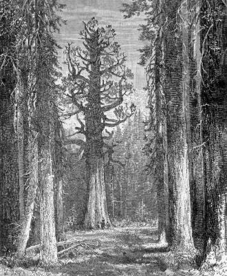
A sequoia grove — illustration by John Muir.

My respect for aboriginal peoples is generally for their genius for cultural adaptation to a great variety of surroundings; not for altering their surroundings for economic benefit. But, well, they are human after all, so I suppose they’re bound to meddle with things.

More objectively, the basic problem with the landscape-altering aboriginal hypothesis with respect to the Sierra Nevada is that it doesn’t appear to be supported by the facts. There is evidence that indicates that Native Americans did use fire to manage vegetation in the immediate vicinity of villages and summer camps, but the vegetation of the Sierra as a whole appears to have been much more under the influence of climate, topography, geology, and other non-human factors.

The idea that Indians managed the forests of the Sierra Nevada with systematic controlled burns appears to ignore evidence that suggests that the forests of the Sierra Nevada are self-managing:

  • The Sierra Nevada is exposed to sufficient lightning, particularly during the dry season, to make naturally-ignited fires frequent enough to avoid excessive build-up of fuel.
  • Before fire suppression, fires would often smolder until winter, sometimes sparking other fires.
  • Dry conditions in late summer not only dehydrate fuel, but also tend to arrest biological decomposition.
  • Preventing the occurrence of hot wildfires might have prevented the establishment of vegetative communities such as Sequoia groves.
  • Evidence of Indian burning of lands not adjacent to permanent settlements is scanty to nonexistent.
  • Park-like areas of the Sierra so beloved by John Muir, where conceivably man-made, were just as likely a result of the practices of shepherds as that of Indians.

John Muir famously commented on the park-like groves that he witnessed in the Sierra:

The inviting openness of the Sierra woods is one of their most distinguishing characteristics. The trees of all the species stand more or less apart in groves, or in small, irregular groups, enabling one to find a way nearly everywhere, along sunny colonnades and through openings that have a smooth, park-like surface, strewn with brown needles and burs. Now you cross a wild garden, now a meadow, now a ferny, willowy stream; and ever and anon you emerge from all the groves and flowers upon some granite pavement or high, bare ridge commanding superb views above the waving sea of evergreens far and near.
—Muir, The Mountains of California, Chapter 8

Muir was a man of his time. He is known to have been given to exaggeration, and this is no exception. Other accounts that predated Muir clearly indicated that much of the Sierra was covered with vegetative communities other than Muir’s idyllic park lands. I am inclined to believe that Muir’s descriptions of the Sierra often say more about himself; more about his mental landscape than any objective landscape.

It was this same man who likened Yosemite to a cathedral. It sometimes seems he desired that the wilderness should resemble a great stone church encircled by a cemetery of manicured meadows with well-spaced trees for tombstones.

John Muir’s introduction to the Sierra in 1868 was preceded by hordes of sheep, and sheepmen like himself; shepherds who were known to burn out forest floor litter for the benefit of their own activities:

… mill ravages, however, are small as compared with the comprehensive destruction caused by “sheepmen.” Incredible numbers of sheep are driven to the mountain pastures every summer, and their course is ever marked by desolation. Every wild garden is trodden down, the shrubs are stripped of leaves as if devoured by locusts, and the woods are burned. Running fires are set everywhere, with a view to clearing the ground of prostrate trunks, to facilitate the movements of the flocks and improve the pastures. The entire forest belt is thus swept and devastated from one extremity of the range to the other, and, with the exception of the resinous Pinus contorta , Sequoia suffers most of all. Indians burn off the underbrush in certain localities to facilitate deer-hunting, mountaineers and lumbermen carelessly allow their campfires to run; but the fires of the sheepmen, or muttoneers , form more than ninety per cent. of all destructive fires that range the Sierra forests.
—Muir, The Mountains of California, Chapter 8

It appears that Muir was very much in favor of fire suppression!

Hoofed locusts
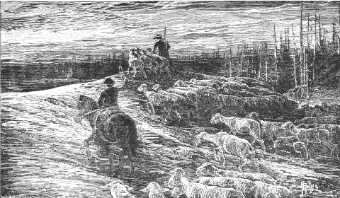
Hoofed locusts — illustration by John Muir.

This reminds me of Muir’s self-serving but eloquent account of his night in a trunk hollow amidst a forest fire near Paradise Ridge in October 1875 (Our National Parks, Chapter IX), and I am inclined to wonder who it was that started that inspiring fire that Muir made so much literary hay of.

When we read about John Muir’s travels through the Sierra, we find, as we would expect, that sheep were quite commonplace. Muir, at last, was not traveling through a virgin wilderness. In many cases, he was probably following livestock trails.

I don’t doubt that open, park-like groves existed in the Sierra before Europeans arrived, and I do value the spacious silence of a Sequoia grove. I also value a path free of obstacles. I’m sure that Indians sometimes burned out brush and forest litter, but I don’t believe that the Indians managed Sierra forest ecology as a whole with systematic controlled burns. Without the fire suppression policies of the 20th Century, there would have been no need for controlled burns. Fires would have found the fuel, and if they didn’t find it immediately, an occasional hot fire fed by “excess” fuel accumulation may have been ecologically beneficial in some respects.

Kilgore (1973) observed that fire is inevitable in the Sierra Nevada, given the climatically dictated imbalance between biomass production (which can be high in most spring and early summer months) and decomposition (which is arrested by dry conditions during summer).
—A. J. Parker, “Fire in Sierra Nevada Forests”

Related entry: The Devil’s Tinderbox

©2008 Dan J. Jensen

A Hockett Trail Guide: 11. Hockett Hill

Welcome to LA. No, there’s not a big green road sign announcing “Los Angeles City Limit” at Trail Pass, but maybe if there were it would not be entirely inaccurate. It is, after all, the City of Los Angeles that runs this place. It’s their water, and their power.

The Hockett Trail proceeded from Trail Pass—or possibly Mulkey Pass—down to Cottonwood Creek, then followed the approximate path of present-day Horseshoe Meadows Road, perhaps running a bit higher around Wonoga Peak to avoid some heinous cliffs.

Walt's Point
Horseshoe Meadows Road (completed 1967) at Walts Point.

Exploring the Southern Sierra: East Side indicates that before 1967 the only trail down from Horseshoe Meadows went down Cottonwood Creek all the way to Owens Valley, but that is clearly not the case. It is a well-known fact that the Hockett Trail began at Carroll Creek, where there was once a busy pack station, shown on this map from the Inyo Independent:

Old routes to Mount Whitney

Carroll Creek is now the site of De La Cour Ranch, where cabins and tent cabins can be rented at the foot of Hockett Hill.

After leaving the plains below Lone Pine this trail rapidly climbs the dreaded Hockett Hill. All travelers try so to arrange their journey that this hill is climbed either in early morning or late in the afternoon. The real hill begins where the desert sloping up from Owens Lake meets the main mountain wall. Here a stream from the snow higher up has made a feeble growth of shrubby trees which mark the last shade and water for a long- time… The view from the trail, however, is magnificent… And just as the pines begin to come in more and an occasional patch of snow is seen on the highest ridges (July) the trail will take a little drop and halt before a small stream, the first water since leaving the bottom. This is Little Cottonwood.” — Hubert Dyer, Sierra Club Bulletin, 1893

The views are magnificent indeed, and more than a little frightening to the average back seat driver. I don’t know if I’ve ever seen a more awe-inspiring descent. I find it hard to believe that people actually ride bicycles up this mile-high monster. It makes one wonder how a trail could have been there, but the trail was there. In fact, it is shown on the 1981 Sequoia National Forest map, though it was cut at numerous points by Horseshoe Meadows Road. Much of the cliff faces seen from along that road were of course blasted for that road, and do not predate it. Also bear in mind that broad roads of this kind cannot work around the native cliffs as trails do.

See Exploring the Southern Sierra: East Side by Jenkins & Jenkins: Horseshoe Meadow Car Tour (T109) and Trail Peak Climb (T113). Also see Hiking California’s Golden Trout Wilderness by Suzanne Swedo: Trail Pass, Mulkey Pass, and the Pacific Crest Trail (27).

A Hockett Trail Guide: 10. South Fork Kern

At Tunnel or “Chickenfoot” junction we enter the domain of a slightly different subspecies of golden trout native to the South Fork Kern. This junction was once known as the turnoff to Mount Whitney, but today it is better known as the boundary of two very special watersheds; a boundary that was once infamously compromised to favor one farming community over another.

South Fork Kern Golden Trout

In 1886, Chinese laborers dug a tunnel between the South Fork and Golden Trout Creek to divert water to the former. One account has it that the tunnel was soon dynamited by the constituency of the latter party.

“This narrow, stream-bordered dike is the great landmark for all Whitney travelers, as here the Whitney trail leaves the Hockett. This hranching place is again indicated by a tunnel under the dike which transfers the northern stream almost wholly into the southern. The traveler approaching the forks (Tunnel forks) from either direction will notice the sudden increase in volume of the southerly stream.” — Hubert Dyer, Sierra Club Bulletin, 1893

This is the starting point of two fishing trips: one up Golden Trout Creek, on the Siberian Pass Trail, and another down the South Fork Kern River, on the Ramshaw Trail. Add to those trips Golden Trout Creek as it flows down to Kern Canyon and the upstream South Fork, and Tunnel begins to look like a great base camp.

Once you’ve got your fill of this great golden trout junction, proceed east on the Trail Pass Trail, along the north edge of Tunnel Meadow. Look for a corral about midway, then an abandoned airstrip, which we might call Tunnel International Airport, toward the far eastern end of the meadow.

“THROUGH COOPERATION, Sierra Air ways offers those of our patrons who wish to save time, fast transportation by air, thirty minutes from Lone Pine to our new camp, located in the heart of the Sierra at Tunnel landing field. Tunnel field is the highest airport in the northern hemisphere-elevation, 9,200 feet.” — Chrysler and Cook Pamphlet

The trail then follows the brook that will develop into the South Fork downstream. It may not seem like much at this point, but look again: spot the golden glistening of its native trout?

Eventually the trail pops over a gap and descends into BullFrog Meadow, and finally the cattle pastures of Mulkey Meadow, before ascending northeast toward Trail Pass, the highest point on the Hockett Trail.

Contrary to some popular accounts, the Hockett Trail did not cross the divide at Cottonwood Pass. The route over Trail Pass is shorter, easier, and much better documented among early accounts.

The trail over Mulkey Pass is the shortest, most direct route which may be taken to reach this famous hunting area, although it may also be reached over Cottonwood Pass.” — Chrysler and Cook Pamphlet

More evidence: the Mount Whitney Trail began at Tunnel junction. If the Hockett Trail had climbed over Cottonwood Pass, there would have been no need for the Mount Whitney Trail to go so far south.

“From the summit of the watershed the trail traverses the famous Mulkey Meadows, named after a widely-known Sheriff of early days, and soon strikes the trickling source of the south fork of Kern river. It clings closely to its northern bank for a few miles and then comes out upon a narrow tongue of land, apparently a moraine, lying between two streams, branches of the south and north forks of the Kern, not more than three hundred feet apart.” — Hubert Dyer, Sierra Club Bulletin, 1893

See Exploring the Southern Sierra: East Side by Jenkins & Jenkins: Horseshoe Meadow to Kern River Backpack (T114) and Saddles, Ridges, Passes, and Kern Peak Backpack (T115). Also see Hiking California’s Golden Trout Wilderness by Suzanne Swedo: Tunnel Meadow (30) and Kern Peak (32).