A Hockett Trail Guide: 6. The Western Divide

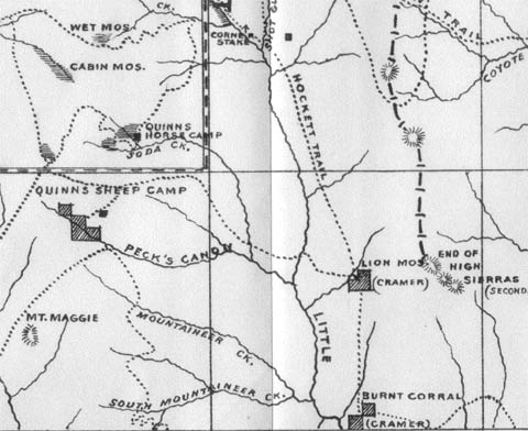
After crossing Hunter Creek, the incline increases as the Hockett Trail leaves the Hockett Plateau for the Western Divide. After ascending 850 feet, the trail reaches a ridgecrest that might deceive a traveler into thinking he’s reached the top, but he has another 300-foot climb ahead. All-in-all, it’s not a difficult ascent to the divide at Wet Meadows Entrance (9824′).

The original boundary of the park actually extended eastward beyond Wet Meadows to a longitude line. Since 1978, the Wet Meadows Entrance has been an entrance into the Golden Trout Wilderness.

The Western Divide is the divide that lies west of the Kern watershed, from Farewell Gap (above Mineral King) to the Greenhorn Mountains. It may be thought of as a branch of the Great Western Divide. It is not, as a whole, given a name on maps, so I take the name from the Western Divide Highway (California State Route 190). It is the first of two divides crossed by the Hockett Trail (the original trail skirted around the Great Western Divide).

On the eastern side of the divide, the trail (31E11) descends toward the Little Kern. The first signs of Wet Meadows bring the trail to a group of large campsites and the roofless remains of a cabin built by the Pitt brothers. At the downstream end of the meadows, there is a rather well-developed camp worth visiting. Be warned, though, that the trail splits at the meadow, and the branch adjacent to the meadow is not maintained.

Below the meadow, the trail encounters a trail to Quinn Patrol Cabin (31E13) on the right. From this junction, trail 31E11 continues toward Mineral King, and we descend in an east-southeast direction into the canyon of the Little Kern, taking care to stay south of the hump that rises just south of Wet Meadows Creek. The descent becomes increasingly more steep into the canyon. The last 400 feet are the worst. This route, once-upon-a-time trail 31E12, has not been maintained, or even used for many years, due to the facts that (1) trails in and out of Mineral King provide alternatives that did not exist in the 1860s, and (2) the Forest Service has not maintained trails in the Golden Trout Wilderness since 1995. Thankfully, some routes are maintained by packers, volunteers, and cowboys. There is hope, however, for this abandoned classic: the 2003 Cooney Fire may have cleared some of it for us.

This leg of the Hockett Trail ends at the Little Kern River, where we reach the first trout stream in the native range of the California golden trout. 31E12 and the old Hockett Trail crossed the stream here, as the canyon is more navigable on the east side. The river is relatively calm here, and the canyon bottom is relatively broad. The outlet stream of Wet Meadows, the Little Kern’s first tributary, flows into the river just upstream. See if you can spot the benchmark 7923 on the east side of the river.

See Exploring the Southern Sierra: West Side by Jenkins & Jenkins: Hockett Meadows–Little Kern River Backpack (T93).
A Hockett Trail Guide: 5. Hockett Plateau

The Hockett Plateau is a glacier-carved plateau at an elevation of about 8500 feet, from 8200 feet along the South Fork Kaweah River to 9500 feet near Summit Lake.

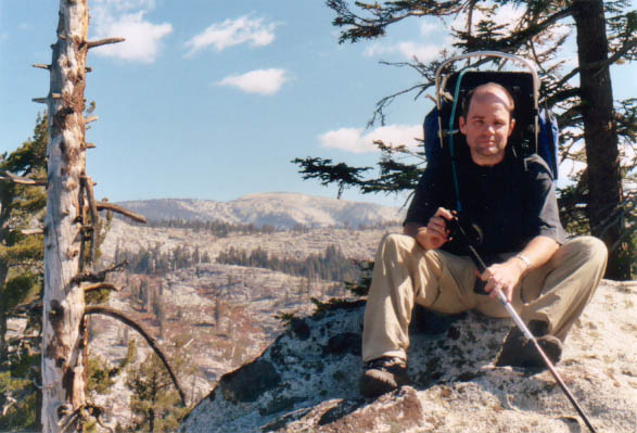
Dan on the western edge of the Hockett Plateau

This sub-alpine tableland can be covered in snow—not to mention mosquitoes—into summer. It features a wealth of meadows, plus a number of glacial tarns well on their way to becoming meadows. Soon after the snow melts, this maze of meadows blossoms into a paradise that has been protected for nearly 120 years now, and so has fared much better than similar meadowlands along the route.

Upon reaching the plateau, the Hockett Trail forded the South Fork Kaweah River, probably at the same point is crosses the river today. Once it crossed, however, it did not ascend the hill to Hockett Lakes as the present-day trail does, but rather proceeded east along the north side of the stream until reaching the far edge of the plateau. Along the way, the trail passes Sand Meadows and South Fork Meadows.

Soon after South Fork Meadows, one comes to a trail junction. The Hockett Trail is to the left and continues along the north side of Hunter Creek. The trail to Windy Gap proceeds to the right, up the South Fork.

The Hockett Trail and the Little Kern

A alternate to the lower Little Kern is accessible via Windy Gap. It crosses less rugged terrain adjacent to Soda Springs Creek, but crosses the Little Kern where the stream has a greater flow, so crossing is a bit more of a challenge. As many historic sites as are offered by this alternate, I have not seen any map from before 1940 (going back to 1896) that shows a continuous trail from Windy Gap to the Little Kern via Soda Spring. Furthermore, no maps or early accounts that I have seen associate that route with the Hockett Trail. Most access to the historic sites along this route, particularly after 1890, was probably via Balch Park Road.

Not long after the Hockett Trail was blazed to the plateau, ranchers drove livestock to its meadows. Clarence King fictionalized such a group of ranchers in his story The Newtys of Pike (Mountaineering in the Sierra Nevada, Chapter 5), based upon his visit to the Hockett Plateau in July 1864. King claimed to have met a family of hog farmers on the Hockett Plateau during this 1864 trip. A Hog farming family was elsewhere reported to have grazed their hogs on Hockett Plateau in 1864 (see Modern Settlement: The Early Explorers ). King appeared to use some license, as was the norm at that time. He may have had the song “Sweet Betsy from Pike” in mind when he wrote the tale.

King took the Hockett Trail as far as Golden Trout Creek, during his second unsuccessful attempt at climbing Mt. Whitney, and then returned on the same trail. He did not have much to say about the Hockett Trail, though at one point he claimed to have found a very pleasant campsite on the plateau; too pleasant, he claimed, to permit him to divulge its location. What little he did say about the trail must of course be subject to skepticism as he tended to take some liberty with his accounts.

Good camping can be found all along this leg of the trail from the river crossing to the confluence of Hunter Creek and the river. Hunter Creek can be a bit unappetizing as a source of water, but it will certainly do in a pinch.

See Exploring the Southern Sierra: West Side by Jenkins & Jenkins: Hockett Lakes–Summit Lake Backpack (T86) and Hockett Meadows–Little Kern River Backpack (T93).
A Hockett Trail Guide: 4. Ladybug vs. Garfield

Clough Cave is not the only cave in the South Fork area. There are four that I have heard of, one of which was discovered in 2006 and featured in National Geographic. Hundreds of such caves occur in marble outcrops which appear in the Sierra’s eroding meta-sedimentary shell. There are at least a half dozen such outcrops in the South Fork area.

At South Fork Campground we are confronted by a choice between (a) following the river to Ladybug and (b) ascending up the south face of the canyon.

The original Hockett Trail stayed near the river to just beyond Ladybug. This is the most direct route, but it requires two additional river crossings, and adds a very steep ascent after Ladybug.

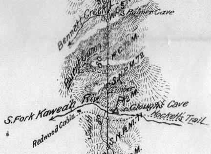
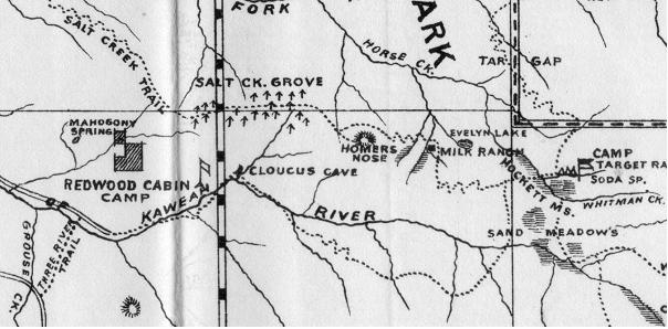
The Hockett Trail and the South Fork, 1896
The Hockett & Salt Creek Trails (1896)

The difficulty of the second crossing is not trivial. It is in a small gorge, and the river rushes precipitously downhill there. I lost a water bottle several years back attempting to ford the river just upstream. The last bridge that crossed at Ladybug was washed out (as were others) in the winter of 1969. After that, the Hockett Trail was no longer maintained from end to end, unless one considers the Garfield-Hockett Trail a branch of the Hockett Trail, which I do.

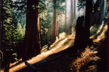
Garfield Grove on an October morning

The reasons I have for considering the high route through Garfield Grove to be part of the Hockett Trail are:

  1. it is probably a superior route to the original one that was abandoned in 1969
  2. it serves all the needs of the original trail
  3. it is adjacent to the original trail and rejoins it quickly

The original trail does avoid snow in the early season, but I’ll take snow over snow melt just about every time. Consider Christopher McCandless.

Still, Ladybug is a great spot for trout fishing and, of course, lady bugs.

My friend Juan and I recently attempted to follow the old ascent up the big hill, but found that it was every bit as overgrown as we had been told. We found ourselves crawling through low-lying tunnels under thickets, hoping to come though to an opening, but the tunnels just kept on going.

Nothing that a good fire couldn’t fix.

The alternative is a long, strenuous haul up the north side of Dennison Ridge, but it offers plenty of shade, moderate slopes, frequent water sources, beautiful forests, stately campsites and all without any drowning hazard. Even with ice on the ground, this route is quite safe in most places.

One of the last wild nesting sites of the California condor before its reintroduction was a fire scar in a giant Sequoia tree, just on the other side of Dennison Ridge. Dennison Ridge, Dennison Peak, and Dennison Mountain get their names from a mountaineer who blazed the first trail across the southern Sierra. It is said that he died after stumbling over his own bear snare, just on the other side of this ridge that bears his name. Dennison's Chili

Legal camping on the Garfield route begins at Snowslide Camp, just beyond Snowslide Canyon, source of the infamous 1876 slide, what I like to call the “Centennial Slide” as a mnemonic. Downstream, at canyon bottom where the slide planted a small Sequoia grove, is the first legal campsite along the old route: Ladybug Camp. Above Ladybug, the old trail gets mighty steep and dry, so there isn’t really any other good camping along this leg of the old route.

See Exploring the Southern Sierra: West Side by Jenkins & Jenkins: Hockett Lakes–Summit Lake Backpack (T86) and South Fork Kaweah River Day Hike (T87).

A Hockett Trail Guide: 3. South Fork Drive

This leg starts just above the South Fork bridge where the Old Three Rivers Highway meets Sierra Drive. The original route was probably closer to the path of present-day Cherokee Oaks Drive, but that’s a dead end. What is today called the Old Three Rivers Highway ends at South Fork Drive, which our route follows to its end. South Fork Drive was not completed into Sequoia National Park until well into the 20th Century. The upper portions of the drive were until fairly recently considered the Hockett Trail. Well after the time cars were driving to Giant Forest, and after backpackers were crossing great iron bridges along the High Sierra Trail, there was still no road entering Sequoia National Park along the South Fork. The road ended at Cahoon Ranch, well outside the park. The upper portion of the road that was later cut and blasted out of the mountainside remains quite primitive, and can offer quite a bumpy ride.

The Hockett Trail's entry into Sequoia National Park

The Hockett Trail’s entrance into Sequoia National Park, 1899.

South Fork Drive crosses the river three times, each a potentially critical watering hole. Cinnamon Creek is also a useful water source. Always treat water at these elevations, unless you get it out of someone’s spigot.

My best guess is that the three river crossings represent the 2nd, 3rd, and 4th crossings of the original Hockett Trail over the South Fork. The terrain appears to dictate these crossings. The first crossing was probably well above the present-day Sierra Drive bridge over the South Fork. The old Hockett Trail probably crossed the South Fork at seven places.

This leg probably should not be attempted in August. My brother and I bicycled up from Tulare as teenagers, and suffered. We walked our bikes most of the way up from Three Rivers. It is probably best attempted on bicycle, just use a bike that’s been maintained, and be prepared for a workout: the elevation gain is 2800 feet. On the other hand, it’s a very enjoyable return ride, with reasonable grades and light traffic. One can always drive, of course, but don’t forget to stop and smell the cow pies. There is some very pleasant country along South Fork Drive.

See Exploring the Southern Sierra: West Side by Jenkins & Jenkins: Highway 198 Car Tour (T84).

A Hockett Trail Guide: 2. Kaweah River Valley

Today, much of this segment of the Hockett Trail is under the high water line of Lake Kaweah, but Sierra Drive (California State Route 198) follows the route faithfully along the south side of the lake to the South Fork, which is the stream that the Hockett Trail followed to the Kern-Kaweah Divide.

One of the prominent peaks along this leg of the route is Tharps Peak, named after Hale Tharp, who had a ranch at Horse Creek, just above the river. This is near the present location of Horse Creek Campground.

Tharp had visited the area in 1856, and returned in 1858 to develop his ranch. He is remembered most for his home in a Sequoia log in Giant Forest, but he is also remembered as the first white man to settle in the area. By the time Hockett Trail development began in the winter of 1862–63, he had begun to explore the area, and had perhaps seen Mineral King in 1861. Tharp here recalls the unraveling of Indian affairs just before the Hockett Trail was blazed through the area:

“By the spring of 1862 quite a number of whites had settled in the Three Rivers section, and the Indians were gradually forced out. Then, too, the Indians had contracted contagious diseases from the whites, such as measles, scarlet fever and smallpox and they died off by the hundreds. I helped to bury 27 in one day up on the Sam Kelly place. About this time Chief Chappo and some of his men came to see me, and asked me to try and stop the whites from coming into their country. When I said that was impossible, they all sat down and cried. They told me that their people loved this country, did not want to leave it, and knew not where to go. A few days later Chappo came to me with tears in his eyes he’d told me that they had decided not to fight the whites, but would leave the country. From that time on, they moved out little by little and from time to time until all were gone.” —Walter Fry, “Hospital Rock in Sequoia National Park,” page 3.

The Hockett Trail was developed during the drought of 1863–64. The drought was driving ranchers up into the Sierra for pasture, and it’s unlikely that there was anywhere left for the Indians that remained. The last account of an Indian village in this part of the Sierra was in 1865, about the time commercial and military traffic ceased on the Hockett Trail.

See Exploring the Southern Sierra: West Side by Jenkins & Jenkins: Highway 198 Car Tour (T84).

A Hockett Trail Guide: 1. The Kaweah Delta

Accounts vary as to the starting point of the Hockett Trail. Most reports have it that the trail started at Visalia, and some specify the Union Army fort in that town. Other sources report that it began at Hale Tharp’s ranch on Horse Creek, now under the high water line of Lake Kaweah. The likely explanation for these variations is that the trail did indeed begin in Visalia, particularly in light of the fact that the Union Army participated in its development, but that in 1862 no actual development work was needed below Horse Creek, thanks at least to Tharp himself, to say nothing of Valley traffic on the Jordan Trail, the Dennison Trail, and Butterfield’s Overland Stage route between Saint Louis and San Francisco.

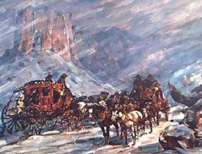
The Butterfield Overland Stage
The Overland Stage

As far as segmenting the trail is concerned, Horse Creek is probably not the best natural terminus for the first leg of the Hockett Trail. The best spot for an end to this initial segment is probably the gap between Limekiln Hill and Lemon Hill that forms a gateway between the Kaweah Delta and the Sierra.

There is some question as to what route the Hockett Trail took between Visalia and the Sierra, but it is most likely that the trail followed a route similar to the present-day path of Sierra Drive (State Route 198), given knowledge of the locations of area settlements and other trails in the early 1860s. The Jordan Trail, for instance, is known to have started near Rocky Hill, just south of Sierra Drive. One of the earliest settlements in Tulare County was probably a bit north of Sierra Drive, on one of the branches of the Kaweah River:

“The southern portion of Mariposa county so cut off, shall be called Tulare county. The seat of justice shall be at the log cabin on the south side of Kaweah creek, near the bridge built by Dr. Thomas Payne, and shall be called Woodsville …” — Act of the California Legislature, 1852

Woodsville, first settled in 1850, was in the neighborhood of the present-day Kaweah Oaks Preserve, seven or eight miles east of what would later become Visalia. This was the site of a historic massacre of white settlers by local “Kaweah” Indians in December 1850. From 1858, the stage road between Stockton and Los Angeles went through Woodsville. It seems it would have been silly for the Hockett Trail to miss Woodsville, though the Overland Stage was moved north to Placerville a year before construction on the Hockett Trail began. Knowing this, it seems quite likely that the Hockett Trail approached the Sierra south of the Kaweah River.

The best route to take today is therefore along Sierra Drive (SR 198). This takes us from downtown Visalia, directly past Kaweah Oaks Preserve and the site of Woodsville, and also directly past the Jordan Trail historic landmark at Yokohl. After passing over the easternmost branches of the delta, the route approaches the portion of the Sierra that appears to be sinking into the Valley, allegedly due to a convection cell in the mantle beneath Visalia. As one travels toward the hills, there are hills buried beneath ones feet.

Sierra Drive’s hillside approach continues to be the likely route of the old trail as it turns northeast toward Lindcove, Goodale, Citro, and Lemon Cove, inasmuch as keeping closer to the river would have meant encountering floods in Winter and Spring.

As the route leaves Lemon Cove, it’s likely that Sierra Drive strays from the original route by climbing the slope south of Lemon Hill, but we can’t exactly travel through the dam, so we stick to Sierra Drive.

See Exploring the Southern Sierra: West Side by Jenkins & Jenkins: Highway 198 Car Tour (T84).

The Devil’s Tinderbox

From the first crossing of the South Fork Kaweah River above Three Rivers (elev. 962 ft) to tree line on Hockett Hill above Owens Lake (approx. elev 6700 ft), the Hockett Trail is, with few exceptions, a forested trail. Even the Coyote Pass alternate over the Great Western Divide is well-forested. The only places where trees do not accompany the trail are where it crosses the Malpais lava flow and large meadows such as Tunnel, Mulkey, and Burnt Corral Meadows.

There are few places, however, where the woods that accompany the Hockett Trail could be rightly described as rain forest. Perhaps portions of Garfield Grove might be described as such with some imagination, but the original Hockett Trail didn’t even have that (it was routed below the grove on a sunny ridge).

There are streams, but nearly no lakes. Kern and Little Kern Lakes were born of landslides in 1867/8, after the Hockett Trail’s creation. Kern Lake is more of a marsh at present than a lake, and will soon be a meadow. Little Kern Lake might necessarily need to drop the adjective from its name.

The southern Sierra Nevada is drier than the rest of the range, but there’s no lack of growth, and in many places undergrowth. In fact, the southern Sierra has forests and even chaparral at elevations where there would only be tundra in other parts of the range.

I’ve often encountered forest fires on or near the Hockett Trail. That ought to surprise no one, with all the sunshine and firewood at the ready.

I missed the 2002 McNally Fire, which spared the Hockett Trail, but managed to burn nearby Hockett Peak.

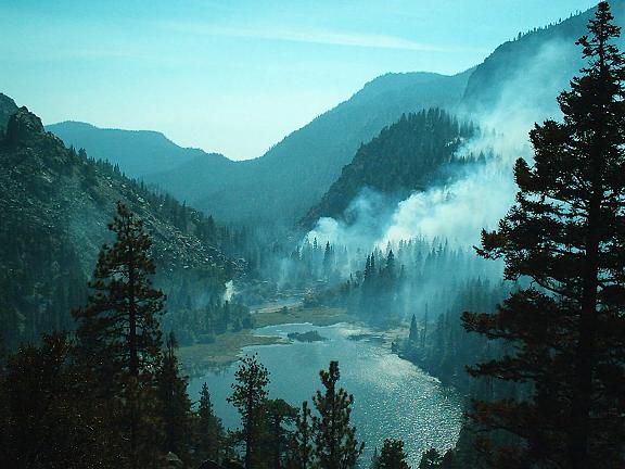
Little Kern Lake during the West Kern Fire.

Little Kern Lake during the West Kern Fire.

The year after the McNally Fire, I had planned to backpack up the Little Kern River, but the Cooney Fire got in the way. My friend Juan and I backpacked up Kern Canyon instead, where we witnessed the West Kern Fire. Two years later, the Kern Fire struck the Kern Canyon. The next time I planned a trip up the Little Kern River was in 2006. That year, the Tamarack Fire got in the way. The Kern Canyon was hit again by the Grouse Fire in 2007. Every one of these 1000+ acre fires—except the McNally—were ignited by lightning.

The Fire Below

Looking back millions upon millions of years ago to the tectonic events that gave birth to the San Andreas fault and California, earth scientists have been striving to determine what forces might have caused the southern Sierra Nevada to lose its root about 3.5 million years ago. It’s a good bet that a range of strange goings on in and around the southern Sierra has been caused by delamination of the subcrustal root of the Sierra: the further uplift of the southern Sierra, subsidence of another portion of the Sierra, tremors and volcanos, and who knows, maybe the 1969 Mets.

One particular event comes to mind: the supervolcanic eruption at Long Valley only 760,000 years ago. You may skeptically inquire, “only 760,000 years?” Bearing in mind that if that infamous supervolcanic explosion-implosion was caused by that splitting of the crust 3.5 million years ago, 760,000 years doesn’t sound like that much. It is as though the initial delamination occurred two weeks ago and a resulting supervolcano then occurred just three days ago.

I don’t mean to venture any conjecture about the probability of major eruptions at or near Long Valley in the immediate future, but rather, I wish to submit that whatever general process existed under the southern Sierra Nevada 760,000 years ago is likely to still be an active process. There’s likely to be something very big going on down there.

What was our first clue?

Perhaps our first clue was the abnormally thin crust under the Sierra.

Where is the crust at its thinnest? Curiously enough, the crust under the Sierra appears to be at its thinnest from around Mount Williamson south to Olancha Peak. This zone includes the highest peaks in the Sierra, and the Hockett Trail cuts right through the heart of it.

Then again, maybe our first clue was the abnormal activity detected in the mantle under Visalia.

The “mantle drip” cell that earth scientists have been investigating lately is thought to be centered approximately below Visalia, and the arc of its circumference cuts deeply into the western Sierra; deepest at the Hockett Plateau. Clearly then, the Hockett Trail cuts through the heart of this zone as well.

Then there’s that other clue: the subsidence that CalTech researchers have identified as roughly centered at the Kaweah Delta. Again, this is the domain of the Hockett Trail.

Oh, and one more thing: why does it appear that the western Sierra is rising west of the Kern Canyon Fault? Could recent activity along this fault, which the Hockett Trail follows from Trout Meadows to Golden Trout Creek, betray some tension caused by convection in the mantle west of that fault?

It seems like a lot is going on under Hockett country.

The Golden Trout Trail

The Hockett Trail was first chosen for its efficacy as a trans-Sierra route, and specifically chosen by the Union Army for its usefulness as a trail between forts in Visalia and the Owens Valley. Coincidentally, or perhaps not so coincidentally, the route of that old trail also traces the native range of California’s distinctive sport fish, the California golden trout. In addition, the Hockett route follows streams east and west of that native range. This makes the Hockett route an ideal route for the sport fisherman.

The three watersheds of the golden trout are, from west to east, the Little Kern River, Golden Trout Creek, and the South Fork Kern. The Hockett Trail followed these streams from its crossing of the Little Kern at Wet Meadows Creek, down the Little Kern Valley, up Kern Canyon, Golden Trout Creek, and finally the South Fork Kern.

“Here the trail branches, and there are two routes to Big Cottonwood, two or three miles further on. Both routes are plain. The one following up the east bank of the stream leads over a low divide between Little and Big Cottonwood, and brings one finally to the last-named. Here is an ideal camp; wood, water, grass, and trout are in plenty. The wonderful golden trout of the Sierras are here, in overwhelming abundance. It is no exaggeration to say that the poorest angler can here at almost any time of day catch strings which would drive the frequenter of local streams wild.” — Hubert Dyer, Sierra Club Bulletin, 1893

The attractiveness of the Hockett route isn’t limited to the Kern watershed. On the west side, the Hockett Trail followed the Kaweah River from the Kaweah Delta to the headwaters of the South Fork Kaweah. On the east side, the Hockett Trail followed Cottonwood Creek, stocked with golden trout since 1876, before dropping down “Hockett Hill” into the Owens Valley and turning north toward the Owens River, yet another notable fishing stream of the region.

Today, the Hockett Trail route and the trout streams along it enjoy wilderness protection from South Fork Campground on the west side to the outskirts of Horseshoe Meadows on the east side, largely due to the creation of the Golden Trout Wilderness in 1978. Unfortunately, fishing on the lower Owens River is not what it was before the Los Angeles Aqueduct, though efforts are being made to restore the stream. As for the state of the trail itself, it is not wholly maintained, and segments of the original trail were completely abandoned as far back as 1969 and 1940. Much of the original route is now paved over, and some of it has been under Lake Kaweah since 1962.

The Early Hockett Trail

The trans-Sierra supply route of the Civil War period commonly known as the Hockett Trail was completed in 1862-63 for two functions:

  1. moving miners and supplies to and from mines in the Coso Range east of the Sierra.
  2. moving soldiers and their supplies to and from Fort Independence (AKA Camp Independence). This was primarily to defend and promote the interests of white settlers against local Indians.

The first function, the commercial reason for the trail, is the reason why the trail was named after the Visalia businessman John Hockett. For this same reason, the Hockett Trail may also rightly share the name “Coso Trail” with the Dennison and Jordan Trails.

The second, military function is the reason why it was also called the “Trail to Fort Independence”. Hockett and the Union Army worked together in developing the trail.

The Hockett Trail found other uses before it was even completed. It served as a route for discovering and accessing new Sierra peaks and valleys. Mineral King was discovered by a hunter on the Hockett Trail crew in 1862 (Hale Tharp later claimed to have visited Mineral King earlier, but even if he did his visit had no historical impact). Ranchers appear to have used the trail to move their livestock to the Hockett Plateau during the drought of 1863.

Though the Hockett Trail was the primary trail across the southern Sierra throughout the late 19th Century, it probably did not serve the Cerro Gordo mines, as they were not generally known until after the Hockett Trail lost much of its purpose as a supply route with the completion of the McFarlane toll road over Greenhorn Mountain in 1864, the opening of a stage service on that road in 1865, and the end of the Owens Valley Indian War in 1865.

The city of Los Angeles gained dominated trade with Cerro Gordo by 1868, and her geographic advantage over Visalia became clear. By 1905, as work on the Los Angeles Aqueduct began, Owens Valley was in practical terms within LA’s city limits.

The completion of Mineral King Road in 1879 diverted traffic away from the westernmost segment of the Hockett Trail, but it may have made the rest of the trail even more popular. The original Hockett Trail, often labeled the Trail to Fort Independence, can be seen skirting around the end of the Great Western Divide on area maps throughout Sequoia National Park’s first decade (the 1890s).

“The Hockett trail was made in early days, and to-day it remains a plain, well-blazed track from Lone Pine through to Visalia.” — Hubert Dyer, Sierra Club Bulletin, 1893

Mountaineering, golden trout, and the establishment of Sequoia National Park kept the trail popular into the 20th Century. The first people to climb Mount Whitney, America’s highest peak until 1959, were fisherman who used the Hockett Trail to get to the Kern River, and the Hockett route continues to give sport fisherman access to some of the most striking freshwater fish in the world.