The Hockett Plateau is a glacier-carved plateau at an elevation of about 8500 feet, from 8200 feet along the South Fork Kaweah River to 9500 feet near Summit Lake.
This sub-alpine tableland can be covered in snow—not to mention mosquitoes—into summer. It features a wealth of meadows, plus a number of glacial tarns well on their way to becoming meadows. Soon after the snow melts, this maze of meadows blossoms into a paradise that has been protected for nearly 120 years now, and so has fared much better than similar meadowlands along the route.
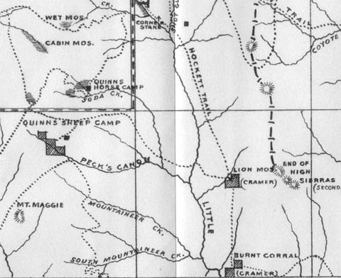
Upon reaching the plateau, the Hockett Trail forded the South Fork Kaweah River, probably at the same point is crosses the river today. Once it crossed, however, it did not ascend the hill to Hockett Lakes as the present-day trail does, but rather proceeded east along the north side of the stream until reaching the far edge of the plateau. Along the way, the trail passes Sand Meadows and South Fork Meadows.
Soon after South Fork Meadows, one comes to a trail junction. The Hockett Trail is to the left and continues along the north side of Hunter Creek. The trail to Windy Gap proceeds to the right, up the South Fork.
A alternate to the lower Little Kern is accessible via Windy Gap. It crosses less rugged terrain adjacent to Soda Springs Creek, but crosses the Little Kern where the stream has a greater flow, so crossing is a bit more of a challenge. As many historic sites as are offered by this alternate, I have not seen any map from before 1940 (going back to 1896) that shows a continuous trail from Windy Gap to the Little Kern via Soda Spring. Furthermore, no maps or early accounts that I have seen associate that route with the Hockett Trail. Most access to the historic sites along this route, particularly after 1890, was probably via Balch Park Road.
Not long after the Hockett Trail was blazed to the plateau, ranchers drove livestock to its meadows. Clarence King fictionalized such a group of ranchers in his story The Newtys of Pike (Mountaineering in the Sierra Nevada, Chapter 5), based upon his visit to the Hockett Plateau in July 1864. King claimed to have met a family of hog farmers on the Hockett Plateau during this 1864 trip. A Hog farming family was elsewhere reported to have grazed their hogs on Hockett Plateau in 1864 (see Modern Settlement: The Early Explorers ). King appeared to use some license, as was the norm at that time. He may have had the song “Sweet Betsy from Pike” in mind when he wrote the tale.
King took the Hockett Trail as far as Golden Trout Creek, during his second unsuccessful attempt at climbing Mt. Whitney, and then returned on the same trail. He did not have much to say about the Hockett Trail, though at one point he claimed to have found a very pleasant campsite on the plateau; too pleasant, he claimed, to permit him to divulge its location. What little he did say about the trail must of course be subject to skepticism as he tended to take some liberty with his accounts.
Good camping can be found all along this leg of the trail from the river crossing to the confluence of Hunter Creek and the river. Hunter Creek can be a bit unappetizing as a source of water, but it will certainly do in a pinch.
See Exploring the Southern Sierra: West Side by Jenkins & Jenkins: Hockett Lakes–Summit Lake Backpack (T86) and Hockett Meadows–Little Kern River Backpack (T93).

