The Fire Below

Looking back millions upon millions of years ago to the tectonic events that gave birth to the San Andreas fault and California, earth scientists have been striving to determine what forces might have caused the southern Sierra Nevada to lose its root about 3.5 million years ago. It’s a good bet that a range of strange goings on in and around the southern Sierra has been caused by delamination of the subcrustal root of the Sierra: the further uplift of the southern Sierra, subsidence of another portion of the Sierra, tremors and volcanos, and who knows, maybe the 1969 Mets.

One particular event comes to mind: the supervolcanic eruption at Long Valley only 760,000 years ago. You may skeptically inquire, “only 760,000 years?” Bearing in mind that if that infamous supervolcanic explosion-implosion was caused by that splitting of the crust 3.5 million years ago, 760,000 years doesn’t sound like that much. It is as though the initial delamination occurred two weeks ago and a resulting supervolcano then occurred just three days ago.

I don’t mean to venture any conjecture about the probability of major eruptions at or near Long Valley in the immediate future, but rather, I wish to submit that whatever general process existed under the southern Sierra Nevada 760,000 years ago is likely to still be an active process. There’s likely to be something very big going on down there.

What was our first clue?

Perhaps our first clue was the abnormally thin crust under the Sierra.

Where is the crust at its thinnest? Curiously enough, the crust under the Sierra appears to be at its thinnest from around Mount Williamson south to Olancha Peak. This zone includes the highest peaks in the Sierra, and the Hockett Trail cuts right through the heart of it.

Then again, maybe our first clue was the abnormal activity detected in the mantle under Visalia.

The “mantle drip” cell that earth scientists have been investigating lately is thought to be centered approximately below Visalia, and the arc of its circumference cuts deeply into the western Sierra; deepest at the Hockett Plateau. Clearly then, the Hockett Trail cuts through the heart of this zone as well.

Then there’s that other clue: the subsidence that CalTech researchers have identified as roughly centered at the Kaweah Delta. Again, this is the domain of the Hockett Trail.

Oh, and one more thing: why does it appear that the western Sierra is rising west of the Kern Canyon Fault? Could recent activity along this fault, which the Hockett Trail follows from Trout Meadows to Golden Trout Creek, betray some tension caused by convection in the mantle west of that fault?

It seems like a lot is going on under Hockett country.

Watching Whales in the Sink

Much of my childhood was spent in the towns of Hanford and Tulare, in a region once called the Tulare Basin, not far from the dry bed of Tulare Lake. This name “Tulare Basin” might have had more meaning before Tulare Lake was drained for wheat and cotton, but it’s still got that “basin” feel to it, or perhaps “sink” is a better word, with the way the heavier air settles down into it. It’s more than just the southern end of the San Joaquin Valley.

At about the time I became a teenager, I bicycled from Hanford to the brink of the Sierra Nevada, and watched the ghostly hills emerge one-by-one out of the Valley haze. I remember the sense of wonder in coming so close to something other than table-flat. I remember the soft, round foothills jutting suddenly out of the Valley floor like whales breaking the surface of a sea of orange groves.

Whales in the sink

Whales east of Cutler, California

There’s a remarkable story behind those whales that I had not heard about until quite recently.

I was taught in college that the earth’s crust is thicker under continents, and thickest under mountain ranges. Think of it as a characteristic of any floating object: the more that you see floating over the surface, the more there is under the surface; only there’s much more under the surface, as with an iceberg.

It turns out that this is not the case with the southern Sierra Nevada. This mountain range is more like a catamaran than a conventional boat. Under the highest portion of the Sierra, the crust is thinner than 30 km, and the crust doesn’t exceed 35 km in thickness under most of the crest of the High Sierra, as well as the Great Western Divide. All this is thinner than the crust is under Fresno.

The Sierra Nevada is hence thought to have lost its root. Layers under the range are thought to have separated, or “delaminated”. If this occurs to an iceberg, one would expect the iceberg to settle down into the water a bit, but that all depends on the relative density of the ice and the water. What happens when a mountain range looses its root? What happens if chunks of crust are dropped into the upper mantle? Some geologists appear to believe that delamination under the Sierra may have created a deep convection cell that led to even more uplift, and possibly an ancient supervolcano. What’s more, that convection cell appears to still be around, and very much alive.

Root loss, mantle drip, and the Moho hole.

Root loss, mantle drip, and the Moho hole.

Let’s take a conceptual hike. Start at Long Valley Caldera, where one of the world’s great volcanic events occurred 760,000 years ago. Walk across the Mammoth divide, past Devils Postpile National Monument, and down the San Joaquin River to Fresno. For much of your hike across the western slope of the Sierra, you will be waling over another anomaly: there is no clear boundary between the crust and mantle beneath your feet: you’re crossing the “Moho Hole”. You’re also walking over a gigantic “high-velocity drip” convection cell. In some areas, the convection cell presses up on the crust; in other places, pieces of the crust are dripping down into the mantle.

So what does all this have to do with whales?

Look at those whales east of Visalia, then look at the foothills along other parts of the western Sierra Nevada. The latter emerge gently from the plain, but the former shoot right out of the Valley floor like sinking ships, and that’s just it: they must be sinking, and there’s more than thirsty farms at work here. As they sink, sediments from Sierra streams settle in around them, burying the the foothills themselves. What we see, then, are not foothills but mountains.

The Tulare Basin is more than just a stagnant basin that happens to be adjacent to the Sierra Nevada: it is part of the Sierra, and not just because it sits on the low end of a great granitic incline. Likewise, the southern Sierra Nevada is much more than just a giant slab of granite. When realizations like these dawn upon us, so too are we reminded that science is more than an accumulation of knowledge: it’s a thing of beauty.

Don’t take my word for it, of course. No doubt I’ve read some of the science wrong. Read it for yourself and let me know what you think:

George Zandt, University of Arizona, 2003:
The Southern Sierra Nevada Drip and the Mantle Wind Direction Beneath the Southwestern United States


George Zandt, Hersh Gilbert, Thomas J. Owens, Mihai Ducea, Jason Saleeby & Craig H. Jones, in Nature 432, 2004:
Active foundering of a continental arc root beneath the southern Sierra Nevada in California


Jason Saleeby and Zorka Foster, CalTech, 2004:
Topographic response to mantle lithosphere removal in the southern Sierra Nevada …


Elisabeth Nadin and Jason B. Saleeby, CalTech, 2005:
Recent Motion on the Kern Canyon Fault, Southern Sierra Nevada, California … (link broken)

What is California?

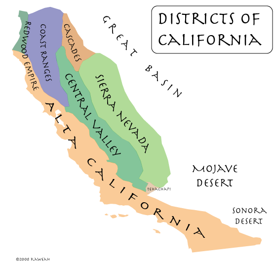
California Districts

An enumeration of the elements of California might proceed as follows:

  1. The San Andreas Fault
  2. The California Current
  3. The Sierra Nevada
  4. The Central Valley
  5. Redwood Forests

The San Andreas Fault

The Pacific and North American Plates, two of the world’s largest, collide from the Gulf of California to Shelter Cove, just south of Cape Mendocino, California. This collision, roughly delineated by the San Andreas Fault, is what put the place we call California on the map.

The California Current

California is probably best known for its climate, a phenomenon which owes no small sum to the fact that California is a collision between continental and oceanic plates, with two particular circumstances:

  1. The collision has a north-south orientation, with cool ocean currents flowing from the north.
  2. The collision occurs across a broad spectrum of tropical, subtropical, and temperate latitudes, from 23 to 40 degrees north.

All this adds up to a mild, sunny climate. Add to that an occasional quake to keep everybody on their toes, and you have the California of the Padres.

The Sierra Nevada

Another California was born in 1848, not of sunshine and mild weather, but of greed. That rebirth was initiated and sustained by four gifts of the Sierra Nevada:

  1. gold
  2. water
  3. soil
  4. beauty and recreation

The massive Sierra Nevada traps large volumes of atmospheric moisture, leaving the lands to the east dry. It being a large mountain block, much of that moisture is stored as snow and ice, meaning that the moisture is released when it is needed most, during the warm, dry springs and summers. As that moisture is released, it carries with it the sediments that become the soils of the great Central Valley.

As lady luck would have it, a smattering of that sediment is gold. It was the glitter of gold in Sierra streams that set the tone for the future of California and America, just as that glitter brought the world to California before her greatest riches were discovered. Beyond the extravagance of gold and the practical benefit of water and soil, we must not forget the beauty and recreational value of Lake Tahoe, Yosemite, the High Sierra, and the Giant Sequoia (more on that to come).

The Central Valley

Without Sierra Nevada sediments, much of the Central Valley might be known today as the Central Sea, like the Sea of Cortes (the Gulf of California) to the south, but the Sierra Nevada does not entirely account for the Central land form of California, be it land or sea, and there are other mountains that feed the Central Valley. The Sacramento River is proof of that. The Sacramento River is fed by the southern end of the Cascade Range on east, and the Trinity Mountains and other ranges on the west.

Redwood Forests

“From the redwood forests to the Gulf Stream waters, this land was made for you and me.” — Woodie Guthrie

Another natural resource that plays a central role in the California myth is the California redwood tree, which lives along the western slopes of the Sierra Nevada and the Pacific Coast, from Big Sur the far southern Oregon.

Where is California?

Having taken all these elements of California into account, a natural eastern boundary of California can be seen to proceed along the following features:

  1. The east coast of Baja California.
  2. The Colorado River.
  3. The crest of the Chocolate Mountains (just east of the San Andreas Fault).
  4. The crest of the Little San Bernardino Mountains.
  5. The crest of the San Bernardino Mountains.
  6. The crest of the San Gabriel Mountains.
  7. The crest of the Tehachapi Mountains.
  8. The eastern edge of the Sierra Nevada.
  9. The eastern edge of the Cascade Range. The boundary continues northward here to include the watershed of the Sacramento Valley.
  10. The crest of the Siskiyou Mountains.
  11. The northern boundary of the Smith River watershed. This is the approximate northern boundary of the region called “the Redwood Empire”.


California As Collision

Along the northeastern shore of the Great Ocean, a long, thin strip of land stretches 1500 miles, in about as straight a line as Nature will allow Herself to draw. The strip is born of the grinding of the great oceanic plate against the continental plate.

From Cabo San Lucas to Cape Mendocino, California is characterized by a system of strike-slip faults between the Pacific and North American plates, but California is more than a mere side-swipe; it is a collision, and this intercontinental collision involves—like so many others—one continent wedging under the other. In this head-on component of the collision vector is born the Sierra Nevada.

The uplift of the Sierra Nevada has not been gentle. It was associated with one of the most powerful earthquakes in California history, the Great Lone Pine Earthquake. It has also been associated with one of the most fantastic volcanic events known to science: the Long Valley supervolcano.

Sierra California

The boundary between Southern and Northern California ignores the compass points, wrapping around the San Joaquin Valley from Tejon to Tehachapi and northward along the Sierra Crest to Tioga and around the northern limit of the Mono Basin. This is made necessary by the Sierra Nevada. The Los Angeles Aqueduct is perhaps the strongest argument for this suggestion, but there is further evidence. If you live in San Francisco, you probably don’t ski at Mammoth, because you’d usually have to drive 220 miles over the Sierra Nevada to Gardnerville, Nevada and drive 120 miles down US-395—over three mountain ranges—to get there. If you live in downtown Los Angeles, it’s 310 easy miles to Mammoth, and Mono Basin is 20 miles farther.

Besides being the highest and perhaps the most monolithic mountain range in the contiguous 48 states, the Sierra Nevada is essential to California in terms of physiography, history, economy, culture, and conscience. But this preeminent position is not merely a matter of gold, pioneers, mammoth cliffs, sky-high waterfalls, giant trees, and alpenglow. The physiography, history, economy, culture, and conscience are as much a matter of water as anything else.

Though the first image of California may be that of a sunny beach, it’s hard to imagine California without the Sierra Nevada and the valleys at her feet. About three quarters of the readily available surface water originating in California flows off Sierra Nevada slopes, and nearly all of the remainder flows along the foot of the Sierra Nevada in the Sacramento River. Though sunshine is what has drawn the millions to California, it is water that has allowed them to remain, and to grow a multitude of sun-loving crops, many of which have become synonymous with the state.

The fact that the Sierra Nevada provides so much water to California is not merely due to the fact that it’s the biggest mountain range around. The range looks as though it were designed to be a great dam to capture the moisture of the great westerly stream pouring off the Pacific Ocean. The dam extends four hundred miles from North to South, capturing over 20 million acre-feet a year. Like the reservoirs and diversions of the Los Angeles Aqueduct, the Sierra Nevada greedily hoards the waters of life for California, leaving the lands downstream barren and uninhabited.

As with any dam, the effectiveness of the Sierra Nevada is a direct product of its location, its shape, its orientation, and its height. Beyond its utility, its grandeur is not any more a product of its height than of its shape and its mass. Nowhere is this more pronounced than along its most massive segment, the great crest between the Tulare Basin and Owens Valley. Beginning in the flat expanse of cotton fields where once a great lake lived, one can travel across what is perhaps the most productive land on earth, and ascend to over 14,000 feet to the crest of the Sierra, following the streams that feed the crops, and passing great redwood forests, cliffs, and lakes along the way. There are few gentle slopes along this great ascent, but on the other side, the 10,000 foot descent is breathtaking. Though the air has been wrung dry on the east side, the Sierra provides enough water to support a thriving economy at its eastern foot.

Beyond Owens Lake, the lifeless monument to the thirst of California, lay the truly barren monument to the greed of the Sierra: Death Valley, which is, in terms of extremes, the second hottest spot on the planet. Death Valley lay directly east of Owens Lake, over Towne Pass.

A less direct route to Death Valley can be found by following the ice age spillway of Owens Lake, down the Rose Valley to China Lake and Searles Lake, from there through Pilot Knob Valley and over Wingate Pass into Death Valley. This low road between Death Valley and the foot of the Sierra would have provided the “Death Valley 49ers” a direct route from the old Spanish Trail to the Central Valley and the gold of the Sierra, had they been able to follow it. Indeed, had they used this route across Death Valley, it is likely they wouldn’t have named it Death Valley as they did. Given the time that they passed through, they might have named it Christmas Valley, or maybe Sun Valley, if they thought enough of it to name it at all.